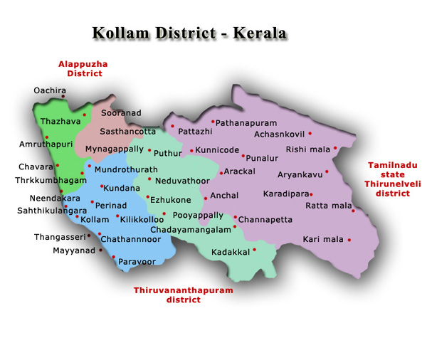
Kollam is one of the 14 districts of Kerala India.About 30 percent of the district is covered by Ashtamudi Lake making it a gateway to the Kerala backwaters.It is endowed with a long coastline, a major Arabian Sea seaport and an inland lake.Kollam District which is a veritable Kerala in miniature is gifted with unique representative features – sea, lakes, plains, mountains, rivers, streams, backwaters, forest, vast green fields and tropical crop of every variety both food crop and cash crop, so called ‘The Gods Own Capital‘.
Kollam is the capital of Kerala’s cashew industry. Plains, mountains, lakes, lagoons and backwaters, forests, farmland and rivers make up the topography of the district.
Kollam District Map
Kollam District Facts
| Headquarter | Kollam |
| Population | 26,29,703 |
| Area | 2,492 Square Kilometers |
| Literacy | 93.77% |
| Sex Ratio | 1,113 Female per 1000Male |
| Official Language | Malayalama, English |
| Official Website | http://www.klm.kerala.gov.in |
| Density | 1056/Sq.Km |
| Taluks | Pathanapuram, Kunnathur, Kottarakkara, Karunagappally, Kollam |
Brief History of Kollam
Kollam, called Quilon by the Europeans, was an ancient port on the west coast.It flourished as a trading centre even in prechristian centuries as can be surmised from the numismatic evidences left by ancient Phoenicians and Romans.The Portuguese were the first Europeans to establish a trading center at Kollam in 1502. Then came the Dutch followed by the British in 1795. A British garrison was stationed at Kollam in pursuance of a treaty between Travancore and the British.
Kollam Geography and Climate
Kollam district is located on the southwest coast of India,surrounded by the mighty Arabian Sea in the west, Tamil Nadu in the east, Alappuzha District in the north, Pathanamthitta District in the northeast and Thiruvananthapuram District in the south.
Kollam’s temperature is almost steady throughout the year. The average temperature ranges from 25 to 32 degrees Celsius. Summer usually runs from March until May; the monsoon begins by June and ends by September. Kollam receives an annual average rainfall of around 2,700 millimetres
Art and Culture
Kollam, the capital of the erstwhile Venad, was a great centre of learning and culture. It attracted distinguished scholars from all parts of south India. Leelethilakam and Unnuneeli Sandesam, two outstanding literacy works of historical importance, is contributions of 14th century Kollam.Kottarakara is well-known as the place where the classical dance form of Kathakali was conceived.Kathakali in its new version of Ramanattam was the creation of Kottarakkara Thampuran, who also improved Krishnanattam by substituting Malayalam for Sanskrit.It was also the capital of the Elayidath Swaroopam.
List of Places to visit in Kollam
Kollam town, the headquarters of Kollam district and Kollam taluk, has a hoary past. It was an international emporium of trade and even now it is a prosperous commercial centre. It is situated about 71 Kms. north of Thiruvavanathapuram and is linked by rail, road and backwater transport. Some of the famous tourist spots of Kollam District are-
- Achencoil
- Anchal
- Aryankavu
- Chavara
- Jetayu Para
- Karunagappally
- Kottarakkara
- Kulathupuzha
- Kundara
- Kunnicode
- Mayyana
- Palaruvi Water Falls
- Pathanapuram
- Paravur
- Punalur
- Sasthamcotta Lake
- Thangassery
- Panmana Asramam
- Thangassery Fort
- Munroe island
- Thevally Palace
- Kollam Beach
- Thirumullavaram Beach
Transportation in Kollam
Road– Kollam has a good network of roads. The State Highway namely, Main Central Road, Kollam-Shencottah Road and Punalur-Pala-Muvattupuzha passes through the district. The National Highway 47 covers a distance of 57.4 kms It is also connected to neighboring states by frequent bus service operated by the Kerala State Road Transport Corporation (KSRTC in the district.The district is well-connected to other parts of Kerala and India by National Highways 47, 220 and 744.
Railways– There are 22 railway station in the Kollam District of which Kollam is an important railway junction.Kollam is the terminal junction of Madras – Egmore – Kollam metre gauge line.
Airways– There is no airport in Kollam District. Trivandrum International Airport is located about 65 km from the Kollam city.
Waterways-Kollam is connected by inland waterway to Alappuzha. The waterways are popular attractions and scenic tourist destinations in the area.The Alappuzha service opens a vast vista of tourist attraction. A full day onboard journey through the backwaters provides an opportunity to witness the natural life of the people around and the scenic beauty of the place.The Thiruvananthapruam-Shornur canal, which forms part of the above system, runs a distance of about 62 kms.

December 4th, 2014 at 9:19 pm
Is there a bridge closure on the waterway from Kollam to Alleppey ( posted December 2014 )
December 6th, 2015 at 9:17 am
this a comment against maxist party. My father was Dr.P.k Sadasivan.he was a homeo doctor.His clinic was near Thaluk Junction .But later shifted to Althara moodu due to Rode vikasanam.His most life was spent for party.But when he was in bed nobody looked him.Is this party Polycy? Now he died.Iam his daughter and widow and having sick.Now D.D.N.P delivering freely in my neighbour house due to influvence.That news felt me so bad in my mind.Thats why My mind force to write one letter to u. One party members daughter can’t buy one news paper .That is nobody careing.Why u can’t delivery free News paper for me.I am living Near Lake ford School.Jawan Junction H.no.61,Kavanadu,Near electric office.