Thiruvananthapuram is the one of the major district of Kerala State of India. It is the southernmost district of Kerala.Thiruvananthapuram, or Trivandrum, as it was conveniently re-christened by the English, is the southern-most district and Thiruvananthapuram city is the district headquarters as well as the State capital of Kerala. Thiru Anantha Puram, or the city of the Holy Anantha, is named after Ananthan, the cosmic serpent with a thousand heads, on whose coils Lord Mahavishnu reclines.The economy of Thiruvananthapuram district mostly consists of tourism and leisure, information technology, agriculture and education.Agriculture has been the primary occupation of the people of the district. Cultivable land may be classified as wet, dry, garden and plantations. Rice is the most important crop cultivated in the wet lands.
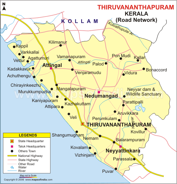
Thiruvananthapuram District Map
Thiruvananthapuram District Facts
| Headquarter | Thiruvananthapuram |
| Population | 33,07,284 |
| Area | 2192 Square Kilometers |
| Literacy | 92.66% |
| Sex Ratio | 1,088 Female per 1000Male |
| Official Language | Malayalama, English |
| Official Website | http://tvm.kerala.gov.in |
| Density | 1509/Sq.Km |
| Taluks | Chirayinkeezhu, Nedumangadu, Neyyattinkara, Thiruvananthapuram. |
Brief History of Thiruvananthapuram
Thiruvananthapuram city and several other places in the district loom large in ancient tradition, folklore and literature.Modern history begins with Marthanda Varma, 1729 CE – 1758 CE, who is generally regarded as the Father of modern Travancore. Thiruvananthapuram was known as a great center of intellectual and artistic activities in those days.The city was the capital of the Travancore state before India’s independence.The state of Kerala came into being on 1 November 1956.
Thiruvananthapuram Geography and Climate
Unlike the flat portion of the Kerala coast, at the northern coastal region of the district, cliffs are found adjacent to the Arabian Sea at Varkala. It is the only part in southern Kerala where cliffs were found. The highland regions on the east and the north-east comprises the Western Ghats, and this area is ideal for major cash crops like rubber, tea, cardamom and other spices. The district stretches 78 kilometres (48 mi) along the shores of the Arabian Sea on the West, Kollam district lies on the North with Tirunelveli and Kanyakumari districts of Tamil Nadu on the East and South respectively.
Climate in the Thiruvanathapuram is generally hot .The large forest reserves favorably affect the climate and induce rains.The mean maximum temperature is 95 °F (35 °C) and the mean minimum temperature is 69 °F (20 °C).December to February are the coolest months. The average temperature goes down to 69 °F (20 °C) in these months.
List of Places to visit in Thiruvananthapuram
Thiruvananthapuram district is considered as the most salubrious segment of Kerala, the ‘Gods Own Country. Proximity of the high mountains on the east and the ocean and lakes on the west has blessed the district with a temperate climate.Tourism has also contributed heavily to the economy of Thiruvananthapuram. The entire tourism package of the state such as hill stations, back waters, beaches, lagoons, and wildlife sanctuaries are present in the district. Some of the famous tourist destination are-
- The Zoological Park
- Sree Chithra Enclave
- Priyadarshini Planetarium
- Chacha Nehru Children’s Museum
- Shankhumugham Beach
- Akkulam Tourist Village
- Veli Tourist Village
- Neyyar Dam
- Meshan Mani
- Sree Chithra Art Gallery
- Natural History Museum
- St. Joseph’s Cathedral, Palayam
- The Folklore Museum
- Sree Mahadeva Temple
- Peppara Wildlife Sanctuary
- Kallar
- Ponmudi
- Agasthyakoodam
- Anchuthengu
- Aruvippuram
- Aruvikkara
- Meenmutti and Kombaikani Waterfalls
- Neyyattinkara
- Poovar
- Sarkara
- Varkala
- Azhimala Beach
- Vizhinjam
- Thiruvallam
- Kovalam Beach
- Sri Padmanabhaswamy temple
- The Napier Museum
Transportation in Thiruvananthapuram
Road– The National Highway 47 stretches from Kaliyikkavila at the southern extremity to Navaikulam near Parippally in the north, covering a distance of 80 km (50 mi) within the district. The MC Road covers a distance of 55 km (34 mi) and passes through Kesavadaspuram, Vembayam, Venjaramoodu, Kilimanoor and Nilamel in the north. PWD maintains about 1,552 km (964 mi) of road in the district. Local bodies maintain 9,500 km (5,900 mi) of road. There are 116 bridges in Thiruvananthapuram District.
Kerala State Road Transport Corporation operates 20 units: nine depots, seven sub depots, and four operating centres in Thiruvananthapuram district.
Railways-Thiruvananthapuram is connected to the rest of the country by broad gauge railway line. The doubling work of the 65 kms. Kollam -Thiruvananthapuram line is completed. Eighty two kms of railway line passes through the district, of which 50 kms. is towards the north (upto Kappil) and 32 kms. towards the south (upto Parassala) from the Thiruvananthapuram Central Station.
Airways– District have Trivandrum International Airport.It is linked with Chennai, Delhi, Mumbai, Hyderabad, Bangalore and Kolkatta by domestic flights.
Waterways-The district’s eastern coastline, and its rivers and lakes, provide ample scope for water transport.

Add Thiruvananthapuram District Feedback, Comments, Reviews